
by Irma Havlicek
Powerhouse Museum Online Producer
Work day 1 – Wednesday 18 October 2012

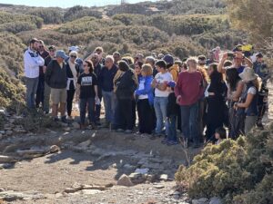
The first thing we did was to walk around the site to familiarise ourselves with it. We looked closely at the site of the temple and also some of the nearby buildings. It was the custom at the time of the Zagora settlement for the altar to be outside the temple; however the situation at Zagora is extremely unusual because the altar is found inside the temple – we don’t know why.
During the first two weeks of this 2012 dig season the site is being surveyed and decisions made about which areas indicate they may be productive if excavated.

Some 40 years on from the first season of excavations at Zagora in the late 1960s and early 70s*, we are able to use more advanced technologies to give us a better idea about what may be beneath the surface of the soil. (More about those technologies in a future post.)
We walked around the perimeter of the site, discussing features as we went. Andrew Wilson, an archaeologist and database specialist representing Arts eResearch at the University of Sydney, walked around the site with a GNSS (Global Navigation Satellite System) receiver. This device is able to plot locations on the site and also record our track around the site. The data is recorded into the device and can then be downloaded into a computer and displayed in a mapping program.

To record positions precisely, Andrew activates the device and holds it still in each position while it records and averages its readings from the satellites. The device receives information from three satellites to resolve its position, and uses a fourth satellite to estimate the accuracy of the position.

For the familiarisation perimeter walk, Andrew plotted the lines between the points, which shows the route we took around the site. That is shown with the red line on the image below.


* It was an Australian team, led by Sydney University Archaeology Professor Alexander Cambitoglou, that in the late 1960s and early 70s conducted (under the auspices of the Archaeological Society at Athens) the first major excavations of the site. This revealed much of the settlement layout, and many of the artefacts discovered are now in the Archaeological Museum of Andros.
2 thoughts on “Site familiarisation”
Sigh. I wish I was there!
We wish you were here too, Wayne. I know how much it means to you.